Taylor Brook Deposit and Taylor Brook Property

Project Overview

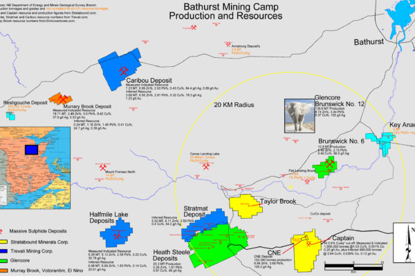
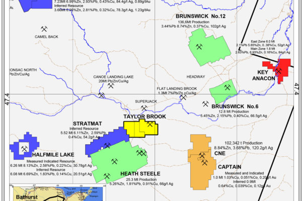
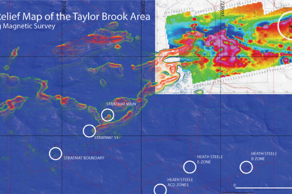
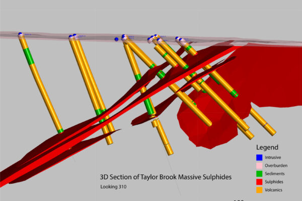
The Taylor Brook deposit is classified as a polymetallic VMS deposit typical of the Bathurst Mining Camp. The deposit is comprised of one to four stratabound horizons of heavily disseminated to semi-massive and massive sulphides with a strike length of approximately 650 metres and a down-dip extent of greater than 600 metres. The Taylor Brook deposit is situated approximately six kilometres along strike and northeast of Trevali Mining Corporation’s Stratmat project and is believed to host mineralization similar to that identified at the Stratmat deposit. The northeast trending Stratmat Shear Zone, which encompasses the Stratmat deposit, appears to be trending onto the Taylor Brook Property. This shear zone is truncated to the north by the Coles Brook Fault that can be mapped on the Taylor Brook Property.

The Taylor Brook deposit appears to have a nucleus of higher-grade massive sulphides concentrated in the northeast area of the Property. Sphalerite and galena are the dominant economic minerals and the width and grades of the base metal mineralization are highly variable within the sulphide zone although several narrow high grade intervals (e.g. 1.0 m. of 10.7% Zn, 2.2% Pb and 5.2 oz/ton Ag in Hole TB95-2) have been encountered. The lead, zinc, and copper ratios are consistent with those from other deposits in the Bathurst Mining Camp. The eastern portion of the Taylor Brook deposit has been drilled to shallow depths and has not been delineated to the east or west nor at depth and remains open.

For a more detailed description of the deposit, please see Walker, 1999 (View Technical Reports).

Exploration

The Taylor Brook Deposit and volcanogenic massive sulphide horizon has been explored by Stratabound Minerals Corp since 1987.

In 1977, Consolidated Morrison conducted an input airborne geophysical survey that identified a coincident EM and magnetic anomaly. Diamond drilling intersected the Taylor Brook base metal sulphide deposit. Follow up drilling by Sabina (1978) and Granges (1986) expanded the deposit but failed to intersect significant grades of zinc and lead.

Stratabound Minerals Corp. acquired the exploration rights to the property by entering into an option agreement in 1988. The historical exploration work was compiled and a new exploration initiative was begun. The program included line cutting, prospecting, horizontal loop EM, magnetic and extensive Induced Polarization (Dipole-Dipole resistivity) surveys. A trenching program was undertaken in the summer and lead to the delineation of a broad area of base metal sulphide mineralization near surface at the western end of the known mineralized horizon. This was interpreted to be a complex re-folded structure that may hold potential for increased grade. Teck Exploration Ltd optioned the property in 1991 and completed geological mapping and lithogeochemical surveys. Two drill holes were added to test the depth extent of the original deposit and yielded disappointing results.

In 2011, Stratabound Minerals commissioned Tetra Tech Wardrop to complete a Preliminary Economic Assessment (PEA) and Resource Estimates on their 100% owned Captain, CNE and Taylor Brook Deposits. Tetra Tech concluded that the Taylor Brook deposit warrants further investigation and development. Tetra Tech recommended that additional drilling be conducted to further investigate and develop the known Taylor Brook deposit. The deposit has not been delineated laterally to the northwest/west. The deposit requires additional work to determine if the continuity of geology and grade continue at depth and laterally to the east. Tetra Tech recommended a definition drill program of approximately 2,900 m.

Additional exploration was conducted in 2012, 2014 and 2016 that increased the level of further exploration and developing the property. Diamond drilling in 2016 intersected the two mineralized horizons that were delineated in DDH 14-39. This further increased the mineralized horizon approximately 75 metres to the south.

Jaeger Resources Corp. optioned the property (claim 1839) from Stratabound in 2017 and initiated exploration.

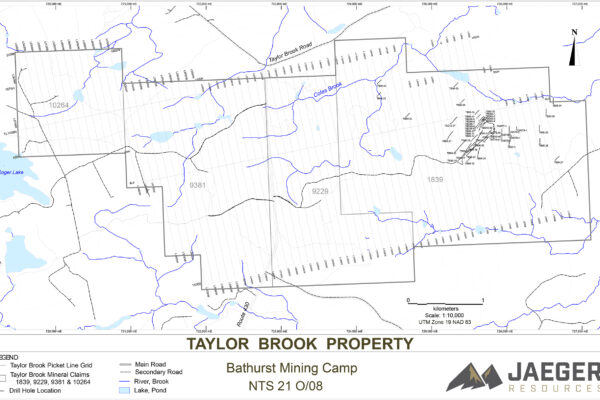
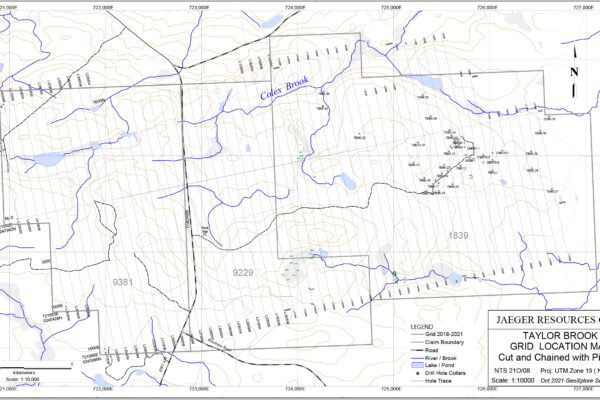
A new grid was cut in 2018 in in anticipation that a major IP conductor exists along a westerly trend.

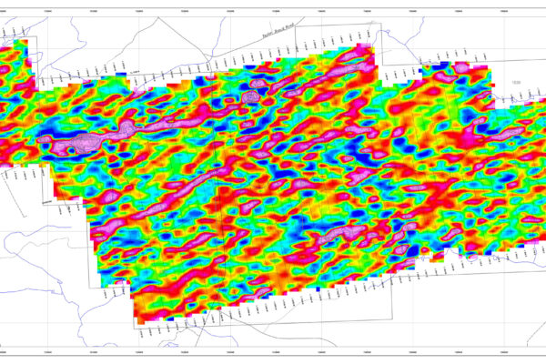
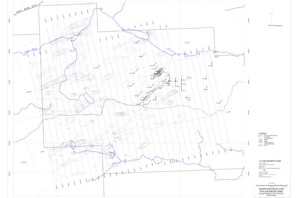
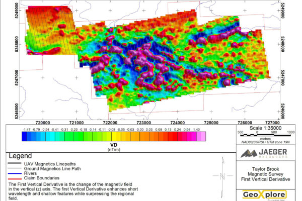
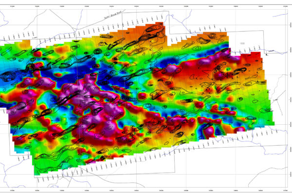
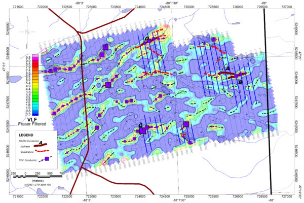
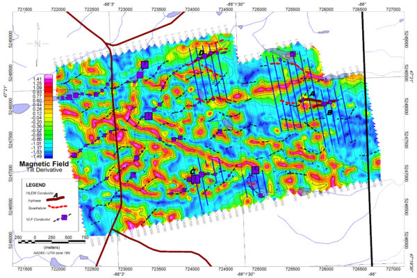
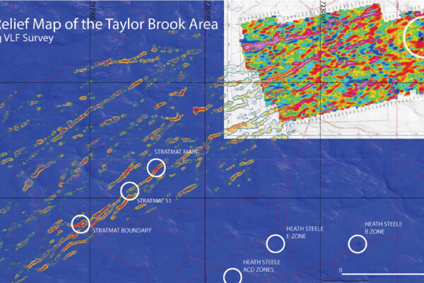
A MaxMin (HLEM) survey was conducted in October, 2018 to better define the drill target anomaly over the new grid. A magnetometer and very low frequency (VLF) survey was conducted in February, 2019 to locate and define potential conductance and magnetic anomalous areas over this new grid. Several magnetometer and VLF anomalies were delineated which necessitated extending the grid to the east and west. These were followed up with magnetometer and VLF surveys in June, 2019 which also delineated several additional anomalies. The grid was again extended to the west October 2019 (40 kms), 2020 (41 kms) and 2021 (29 kms) which has been covered by magnetometer and VLF geophysical surveys.

An exploration program consisting of Horizontal Loop Electromagmetic (HLEM) geophysical survey was conducted in 2020 to follow up on the VLF and magnetometer surveys (2019, 2020) which outlined some anomalous areas of interest. The Taylor Brook deposit was also surveyed. The VLF, magnetometer and HLEM data were sent to a geophysical consultant for interpretations. Additional HLEM survey work was also conducted in 2022.

“The drill holes (mineralized area) appear to flank a magnetic anomaly. Strong VLF-EM and HLEM anomalies are also associated with the mineralized area. Based on these results, further target areas can be based on the initial VLF surveys and should be followed up with HLEM (MaxMin)”. A favourable geological setting together with results of the work done to date show that the property has the potential for additional drill untested geophysical targets.

Lithogeochemical and geometallurgical studies were carried out in 2019 , 2020 and 2021, which are important for understanding the geology, mineralization, waste rock and tailings components of any deposit and their impact on the environment and reclamation. This program also has the potential for discovering and locating additional mineralization on the property for follow up drilling.

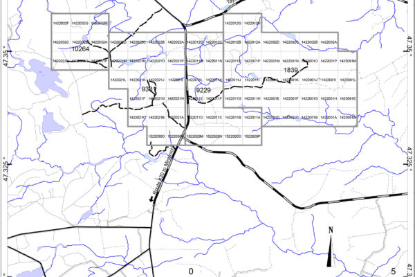
Additional claim blocks (9229, 9381, 10264) were staked by Jaeger Resources to cover the open ground between Taylor Brook Deposit and the Stratmat Deposit property. No exploration has been conducted in these claim blocks since 1998. Limited exploration had been conducted by various companies in this area from 1957 to 1998. These claims comprise the Taylor Brook Property which now includes the Taylor Brook Deposit (claim 1839).
Resources

The 2011 historical mineral resource estimates (NI 43-101 compliant) for the Taylor Brook deposit at 1.60% ZnEQ% cut-off grade are:

  • an Indicated Resource of 243,000 tonnes at 1.69% Zn, 0.85% Pb, 0.02% Cu and 33.42 g/t Ag and
  • an Inferred Resource of 102,000 tonnes at 1.70% Zn, 0.87% Pb, 0.02% Cu and 32.59 g/t Ag.

Please see the PRELIMINARY ECONOMIC ASSESSMENT ON THE CAPTAIN, CNE, AND TAYLOR BROOK VMS DEPOSITS, (View Technical Reports) for details.

Environment & Sustainability

  • Property is not within any designated or proposed park or environmentally sensitive area.
  • There are no apparent designated commercial interests other than logging and mining.
  • The property area does not include any fishing sensitive lakes.
  • There are no known environmental liabilities on site.

Metallurgy

A preliminary geometallurgical study was initiated in 2019 to examine the mineralogy and lithogeochemistry of the Taylor Brook Property.

A preliminary to any mineral processing study must include a mineralogical and lithogeochemical study with emphasis on trace element geochemistry. This study is important for understanding the ore, waste rock and tailings components of any deposit and their impact on the environment. This would include reclamation.

The level of detail from this investigation should increase as the project advances through the various stages of development.

The purpose of this study is as follows:

  • Define in better detail the known mineralogy.
  • Define potential lithogeochem markers (pathfinder elements) relevant to understanding the geology and mineralization.
  • Define any potential deleterious trace elements.
  • Determine if there are different ore types within the Taylor Brook Deposit which would impact recovery and processing requirements.
  • Characterize the potential tailings and waste rock that could be disposed with respect to acid rock drainage and metal leaching.
  • Determine the impact / influence of mineralogically problematic material and/or gangue minerals resulting from any deleterious trace elements.

Highlights of the study include the following preliminary interpretations:

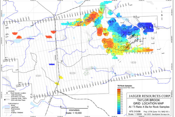
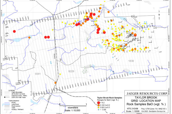
  • An exhalite horizon based on barium (Ba) concentrations has been identified above the mineralized zone in DDH TB95-2, This has not been recognized in previous work. Exhalites generally occur above sulfide deposits and is an important aspect in exploration.
  • Anomalous barium concentrations have been identified in outcrop which correlate with sulphide mineralization. This indicates that the exhalite unit occurs over the property.
  • A Taylor Brook Index [ (Al/Ti)*Ba] can be used to define areas of interest and has a distinct signature in mineralized sections.
  • There is a strontium depletion in the mineralized sections.
  • Titanium can be used to distinguish gabbro / diabase, even when highly altered.
  • Anomalous concentrations of indium and tin occur in some mineralized zones
  • No graphite is present.
  • The elevated As and Sb values in the ore zone samples reflects the minor amounts of tennantite (As end member) - tetrahedrite (Sb end member)
  • Clay material such as sericite (illite / muscovite) is pervasive throughout the units. High concentrations of sericite in samples will impact mineral processing.
  • Mineralization is medium grained. This is an important aspect for mineral processing.
  • The Al / Ti ratio can be used to differentiate lithologies.
  • A portable XRF analyzer can be used for pathfinder elements to identify in the field and in drill core the exhalite unit and mafic / diabase dykes.

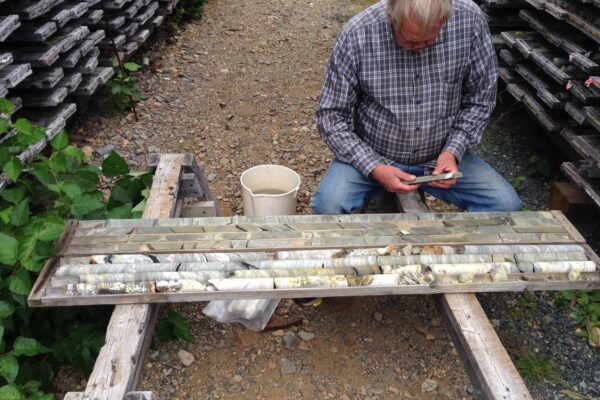
As part of this study, re-sampling of historic diamond drill core of the Taylor Brook Deposit stored at the Madran core facility was carried out. Selected outcrops were also sampled on a newly established cut grid.

With this kind of geometallurgical information at the exploration stage, the Company can begin to fine-tune any future mineral processing systems.

Status

Jaeger Resources Corp ("Jaeger") entered into an option agreement with Stratabound Minerals Corp ("Stratabound") in 2017 (see press release dated February 22, 2017) to earn an 80% interest in 34 of the Taylor Brook Property claims through exploration expenditures, the assumption of Stratabound's work and payment obligations relative to the Taylor Brook claims and the issuance to Stratabound of shares of Jaeger. Under the terms of the agreement Jaeger issued 1,000,000 common shares to Stratabound upon execution of the agreement, an additional 1,000,000 common shares issued to Stratabound on the one-year anniversary of the agreement and Jaeger is required to incur cumulative exploration expenditures of $500,000 over a three-year period (amended to a 6 year period as stated below). To date (November, 2019), Jaeger has expended $125,000 on exploration.

On May 15, 2019 Jaeger entered into an Amending Agreement (the “Amending Agreement”) with Stratabound. The Amending Agreement extends the original agreement to February 22, 2023 and requires Jaeger to make $500,000 (the original exploration commitment) in cumulative exploration expenditures on the Property and maintain the Property in good standing. This includes $125,000 in cumulative exploration expenditures by February 22, 2020; $200,000 by February 22, 2021; and $300,000 by February 22, 2022. Jaeger issued 1,600,000 common shares to Stratabound as consideration for the Amending Agreement. Upon Jaeger's exercise of the option, Stratabound will have the election to enter into a joint venture with Jaeger or to convert its remaining interest to a 3% net smelter return royalty which can be bought out.

The global pandemic COVID-19 has resulted in unprecedented shutdowns, with the government of New Brunswick waiving the work requirements for the 2020 period, and by extending all active claims for a period of one year. As a result of Covid-19, Stratabound and Jaeger have agreed to modify the terms of the Option to extend the dates in the Amended Option by one year. This agreement replaces the 2019 Amended Option.

Infrastructure

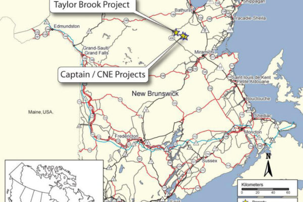
Located in the Bathurst Mining District, Northumberland County, New Brunswick, approximately 45 kilometres  southwest of the city of Bathurst which has a well-developed mining infrastructure and a skilled workforce.

Property is accessed via Highway 403 and/or the Taylor Brook Road. There are several unpaved logging roads that allow easy access to various areas on the Property.

The Taylor Brook Property consists of 34 contiguous optioned claims encompassing 748 hectares and 36 contiguous claims staked by Jaeger encompassing 792 hectares The surface rights are designated as Crown Land and are held by the Provincial Government. Jaeger holds the required Notice of Planned Work permit needed to carry out the  Company’s proposed work program on the Property.

Northumberland County, New Brunswick, Canada
NTS 21 O/08E Latitude: 47 0 21’ Longitude: 66 0 00’

Project Media & Reports

Project Photo Gallery

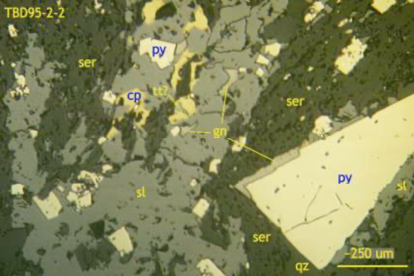
TBD95-2-2

TBD95-2-2: Detailed view of possible deformed quartz-sulfide-minorchlorite vein in sericite schist host rock. Sulfides include euhedral pyrite (py), subhedral sphalerite (sl) that contains local minor chalcopyrite (cp), galena (gn) and rare trace possible sulfosalt (tetrahedrite, tt?). Reflected light, uncrossed polars, field of view ~1.5mm wide.

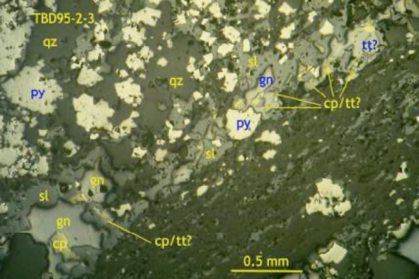
TBD95-2-3

TBD95-2-3: Overview of semi-massive sulfide sample showing alternating bands of fine-grained sericite rich (minor sphalerite, pyrite) rock and coarser-grained, quartz-pyprite-sphalerite-galena-trace chalopyrite, possible sulfosalt (tetrahedrite, tt?). Reflected light, uncrossed polars, field of view ~3mm wide.

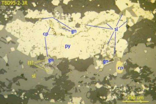
TBD95-2-3R

TBD95-2-3R: Detail of band of sphalerite with pyrite aggregate containing included trails of (relic bedded?) galena, chalcopyrite and sphalerite; note minor possible tetrahedrite (?) associated with chalcopyrite and galena in adjacent sphalerite. Reflected light, uncrossed polars, field of view ~1.5mm wide.

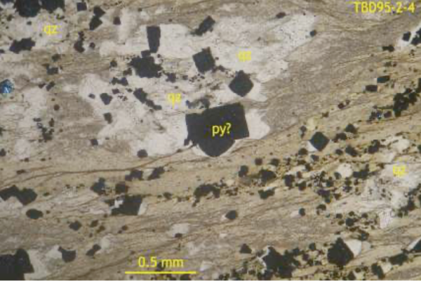
TBD95-2-4

TBD95-2-4: Alternating, disrupted/transposed bands or former layers (?) of very fine-grained sericite-rich rock (with variable small cubic opaques, likely pyrite, and thin whispy foliae or brownish hydrobiotite?) containing lensy aggregates of coarser-grained quartz-cubic opaque (pyrite?) rock. Transmitted plane light, field of view ~3mm wide.

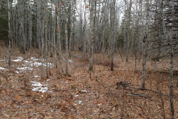
General topography on property. Outcrops are scarce. VLF, magnetometer and HLEM geophysical surveys are best for delineating mineralization.

General topography on property. Outcrops are scarce. VLF, magnetometer and HLEM geophysical surveys are best for delineating mineralization.

Re-sampling core from 1997 drilling program. Core stored at the Madran core facility, Bathurst, New Brunswick

Re-sampling core from 1997 drilling program. Core stored at the Madran core facility, Bathurst, New Brunswick

Project Location